Home Home
  • Home
  • 25 years
  • News
  • Sectors
    • City councils
      • Urban Information Portal (PIU)
      • WebGIS Activities and locations management
      • Castelló City Council
      • Sevilla city council
      • Tarragona City Council
    • Public authorities
      • Expropriation and Heritage Management
      • AMB SDI
      • Catalonia tourist geoapp
      • Puerto de Barcelona
      • Beaches of Mallorca
      • SIGME
      • VUIB
    • Mobility and sustainability
      • Smou
      • Mou-te
      • SPRO
      • TMB
    • Service networks
      • EMAFESA
      • GISAgua
      • WIBDH
    • Companies and businesses
      • Servihabitat
      • Pisos.com
      • CBRE
      • Windtec Energia Eòlica
    • Logistics
      • Eurofins Megalab
      • Interfacom
      • MOBA
      • Veosat
      • Race
      • M.Soft
      • M-Automoción
  • Tools
    • Cercalia
    • enMapa
    • Recitty
    • Custom solutions
    • Bus Manager
  • Contact
    • Contact
    • Work with us
Contact

Breadcrumb

  1. Home
  2. Service networks
  3. Emafesa

EMAFESA

Water Cycle for the provision of the drinking and drainage water supply service of Ferrol

logo emafesa
emafesa

GIS

banner

What have we done?

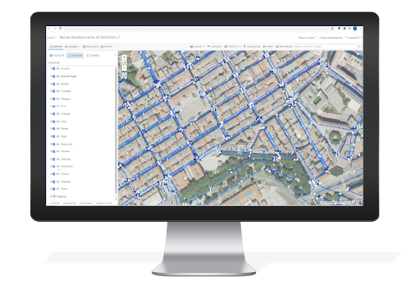
The purpose of the project was to develop a Geographic Information System to make the network information available. To that end, the data were migrated to a GIS environment for their maintenance, use and publication on a web map viewer.

banner

What have we contributed?

  • To define a Supply and Drainage data model.
  • To prepare an ESRI GeoDataBase for dumping the data.
  • To develop a loading process in PostgreSQL/PostGIS.
  • Publication of an ArcGIS Online viewer with GeoServer layers.
  • Creation of a viewer with ArcGIS Online with the GeoServer layers.

Technological environment:

Image

Arcgis
Image
postregsql logo
Image
geoserver logo
Image
GDAL Logo
CONTACT
  • Barcelona Office
    Aragó 264 4, 08007 Barcelona
  • Guadalajara Office
    Av. Buendía 11, 19005 Guadalajara
  • Girona Office
    Joaquim Botet Sisó 6, 17003 Girona
  • +34 93 0172728
    [email protected]
  • TwitterYoutubeLinkedin Instagram
SECTORS
  • City councils
  • Public authorities
  • Mobility and sustainability
  • Service networks
  • Companies and businesses
  • Logistics
NEXUS
  • News
  • Work with us
  • Cercalia
  • enMapa
  • Recitty
  • Contact
OTHERS
  • BusManager
  • Routing Reparto
logo soclogo generalitatLogo eulogo next genenergia renovableENSPymeInnovadora
aeonorISO
Sello PYME INNOVADORA 11/02/2028
PYME INNOVADORA
Válido hasta el 11 de febrero de 2028
escudo de MEIC 11/02/2028
  • Quality, Safety, and Environmental Policy
  • Cookies policy
  • Privacity policy
  • Legal advice
  • Home
  • 25 years
  • News
  • Sectors
    • City councils
    • Public authorities
    • Mobility and sustainability
    • Service networks
    • Companies and businesses
    • Logistics
  • Tools
    • Cercalia
    • enMapa
    • Recitty
    • Custom solutions
    • Bus Manager
  • Contact
    • Contact
    • Work with us