Home Home
  • Home
  • 25 years
  • News
  • Sectors
    • City councils
      • Urban Information Portal (PIU)
      • WebGIS Activities and locations management
      • Castelló City Council
      • Sevilla city council
      • Tarragona City Council
    • Public authorities
      • Expropriation and Heritage Management
      • AMB SDI
      • Catalonia tourist geoapp
      • Puerto de Barcelona
      • Beaches of Mallorca
      • SIGME
      • VUIB
    • Mobility and sustainability
      • Smou
      • Mou-te
      • SPRO
      • TMB
    • Service networks
      • EMAFESA
      • GISAgua
      • WIBDH
    • Companies and businesses
      • Servihabitat
      • Pisos.com
      • CBRE
      • Windtec Energia Eòlica
    • Logistics
      • Eurofins Megalab
      • Interfacom
      • MOBA
      • Veosat
      • Race
      • M.Soft
      • M-Automoción
  • Tools
    • Cercalia
    • enMapa
    • Recitty
    • Custom solutions
    • Bus Manager
  • Contact
    • Contact
    • Work with us
Contact

Breadcrumb

  1. Home
  2. News
  3. Interactive map integral maintenance plan barcelona

Interactive map of the Integral Maintenance Plan (PMI) of Barcelona

Submitted by lvilardell on Tue, 02/11/2025 - 16:38
Image
mapa obres barcelona

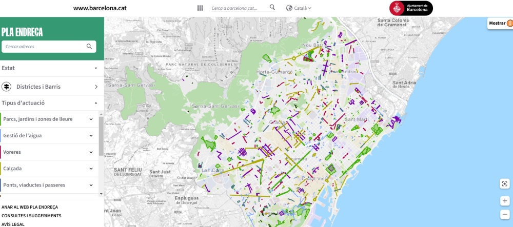
Nexus Geographics has collaborated with the Barcelona City Council and BIMSA to develop an interactive map that allows citizens to check the planned actions in the city until the year 2027 related to the renovation and maintenance of public space. These actions are part of the Integral Maintenance Plan (PMI), an initiative aimed at keeping municipal infrastructures in good condition and controlling the obsolescence of public road elements.

Map at the service of Barcelona residents

The new interactive map can be consulted through the official website of the Plan Endreça, and incorporates various functionalities that facilitate access to information about municipal works:

  • Updated visualization of maintenance interventions throughout the city.
  • Customized filtering: search by type of action, by neighborhood, and also by the status of the works (planned, in progress, and completed).
  • Detailed information: allows access to the data of each project, including dates, exact locations, and descriptions.

Barcelona works map

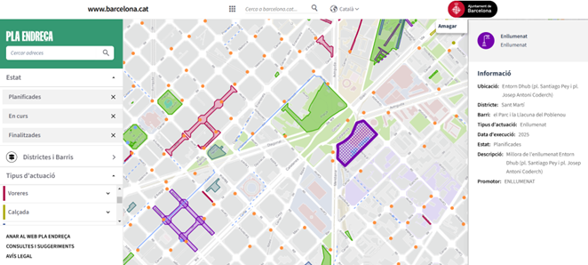
Interactive map to follow, in real-time and street by street, the status of the works

Thanks to this viewer, citizens can stay informed about the works affecting their neighborhood, promoting transparency and citizen participation in the process of maintaining and improving public space.

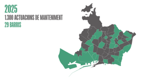
The Integral Maintenance Plan (PMI)

The Plan is an initiative of the Barcelona City Council and BIMSA aimed at improving and conserving public space. For the year 2025, the plan will act in 29 neighborhoods of the city, with a planned investment of 105 million euros. The PMI plans to carry out 1,300 actions, which include:

  • Pavement renovation
  • Modernization of urban furniture
  • Sidewalk rehabilitation
  • Improvement of public lighting

Barcelona works map 2025​

Source: Barcelona City Council

For more information: Barcelona City Council

GIS Solutions for City CouncilsCity Councils

Categories

Congress and conferences
Transport and infrastructure
NexusTeam
GIS Solutions for City Councils
Smart Mobility
City Councils
Awards
Spatial intelligence
Geolocation
Article
APPS

Related news

mapa obres barcelona
Tue, 02/11/2025 - 16:38
Interactive map of the Integral Maintenance Plan (PMI) of Barcelona
pisos
Tue, 02/20/2018 - 00:00
Maps with 3D buildings with apartments and houses on the real estate portal Pisos.com
ematsa
Fri, 02/09/2018 - 00:00
A Touch screen application to inform of field-work water samples
TUS
Mon, 01/15/2018 - 00:00
GIS system of mobility and public transportation of Sabadell
CONTACT
  • Barcelona Office
    Aragó 264 4, 08007 Barcelona
  • Guadalajara Office
    Av. Buendía 11, 19005 Guadalajara
  • Girona Office
    Joaquim Botet Sisó 6, 17003 Girona
  • +34 93 0172728
    [email protected]
  • TwitterYoutubeLinkedin Instagram
SECTORS
  • City councils
  • Public authorities
  • Mobility and sustainability
  • Service networks
  • Companies and businesses
  • Logistics
NEXUS
  • News
  • Work with us
  • Cercalia
  • enMapa
  • Recitty
  • Contact
OTHERS
  • BusManager
  • Routing Reparto
logo soclogo generalitatLogo eulogo next genenergia renovableENSPymeInnovadora
aeonorISO
Sello PYME INNOVADORA 11/02/2028
PYME INNOVADORA
Válido hasta el 11 de febrero de 2028
escudo de MEIC 11/02/2028
  • Quality, Safety, and Environmental Policy
  • Cookies policy
  • Privacity policy
  • Legal advice
  • Home
  • 25 years
  • News
  • Sectors
    • City councils
    • Public authorities
    • Mobility and sustainability
    • Service networks
    • Companies and businesses
    • Logistics
  • Tools
    • Cercalia
    • enMapa
    • Recitty
    • Custom solutions
    • Bus Manager
  • Contact
    • Contact
    • Work with us